Decades of conflict in the Gaza Strip have contributed to widely documented cultural heritage destruction, demonstrating a need to monitor vulnerable sites and enhance the empirical base. This article describes how the Gaza Maritime Archaeology Project (GAZAMAP 2022–2023) was developed to monitor coastal and near-coastal sites, collaboratively. Owing to the unprecedented destruction of heritage since October 2023, GAZAMAP’s scope has fundamentally shifted.
Antiquity, DOI: https://doi.org/10.15184/aqy.2024.68
Georgia Marina Andreou, Archaeology Department, University of Southampton, UK
Yasmeen Elkhoudary, Independent researcher
Ayman Hassouna, Islamic University of Gaza, State of Palestine
Introduction: heritage in Gaza
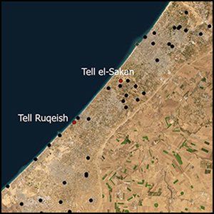
Though the Levant holds enormous influence in archaeological discourses—particularly on maritime connectivity and trade—crucial components of this region, such as the Gaza Strip (Figure 1), are still poorly understood. Systematic archaeological research in Gaza has been hindered since the early 2000s by conflict in the region, resulting in extensive site damage. Compounding the destructive effects of politico-economic restrictions and warfare on Gaza’s heritage are pollution and environmental processes, particularly erosion, which have drastically damaged coastal and near-coastal archaeology (Andreou et al. Reference Andreou, Fradley, Blue and Breen2022).
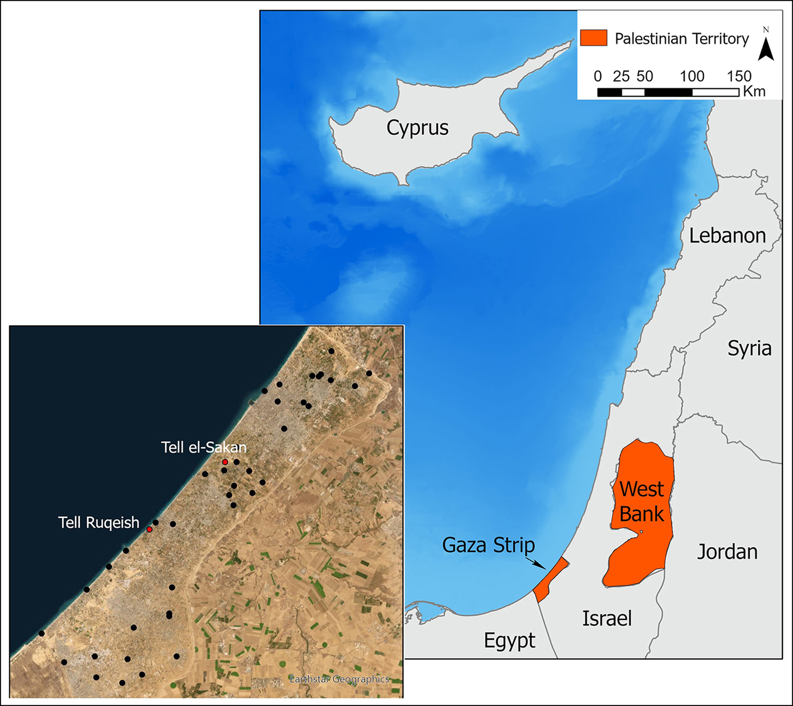
Figure 1. Map of Gaza Strip showing the location of Tell Ruqeish and Tell es-Sakan (figure by authors).
For a broader understanding of Gaza’s archaeology and for a time- and cost-effective documentation of deteriorating archaeological features, landscape archaeology has provided important and accessible tools to monitor sites. However, the feasibility of using these tools in Gaza has been inhibited by a history of settler colonialism, waves of violence and restrictions, spatial data limitations (Zerbini & Fradley Reference Zerbini and Fradley2018) and the prolonged blockade by Israel preventing access to data collection technologies and stymying the development of expertise. Here, we discuss how the Gaza Maritime Archaeology Project (GAZAMAP), a collaboration between the University of Southampton, the Maritime Endangered Archaeology Project (MarEA) and students from the Islamic University of Gaza combined expertise and equipment dispersed in Gaza to develop a programme for archaeological documentation and monitoring. In addition, we discuss how the unprecedented destruction of heritage since October 2023 has changed the project and explain how the work of Gazan heritage students and practitioners offers important insights into the challenges and potential of archaeological work in this region.
Methods
Restrictions on the use of geolocation devices combined with limited funds and expertise on archaeological survey have been impediments to the management and protection of sites in Gaza. Several technologies required for site monitoring (e.g. UAV drones and differential GPS) were available in the region but were dispersed across various sectors largely excluding archaeology. Financial capacity to access these technologies, and the training to use them in heritage and archaeology, have been scarce but could be accessed through the development of long-term and meaningful cross-sector collaborations.
Leveraging this opportunity and previous remote assessments of Gaza’s heritage (Andreou et al. Reference Andreou, Fradley, Blue and Breen2022), the Gaza Maritime Archaeology Project (GAZAMAP) was created in 2021 by a partnership between UK-based and Gazan scholars, initially with an emphasis on coastal archaeology. GAZAMAP created a network of Gazan professionals with various skills, including media-production companies that collected aerial and underwater imagery and an engineering company that produced topographic maps. These companies also trained a survey team, comprising archaeology and geographic information systems (GIS) students from the Islamic University of Gaza and heritage professionals from the Ministry of Tourism and Antiquities.
The University of Southampton delivered remote training on current methods and technologies for coastal archaeology using accessible survey tools, including KoboCollect, an offline, open-access spatial data collection app (https://www.kobotoolbox.org/). The survey team used KoboCollect to record field observations as geotagged photographs, which were then analysed using GIS. The surveys focused on those sites that had been identified, and ground-truthed, as rapidly deteriorating (Andreou et al. Reference Andreou, Fradley, Blue and Breen2022). This article discusses the monitoring of two of these sites.
Tell Ruqeish
Based on extant features, Tell Ruqeish is an Iron Age site with a massive fortification wall (Figure 2) and a coastal zone of approximately 1km (Oren et al. Reference Oren, Fleming, Kornberg, Feinstein and Naḥshoni1986). The site’s coastal location, submerged features that were found in the 1970s and the presence of imported artefacts suggest regular maritime connectivity for at least three centuries (Oren et al. Reference Oren, Fleming, Kornberg, Feinstein and Naḥshoni1986). Moreover, Tell Ruqeish’s location between Rafah and Gaza and on a main route between Egypt and Phoenicia could provide valuable information on trade connections between the Mediterranean and the Near East. Since its first excavation, Tell Ruqeish has remained insufficiently examined. The western segment of the site has almost completely eroded and was until recently partly covered by recreational infrastructure, while materials excavated in the 1970s remain outside of Gazan archaeologists’ reach, thus preventing an in-depth understanding of this Iron Age emporium.

Figure 2. Map of Tell Ruqeish (adapting Oren et al. Reference Oren, Fleming, Kornberg, Feinstein and Naḥshoni1986: 84; the basemap was provided and used with permission of the European Space Agency; figure by authors).
In 2022, GAZAMAP revisited Tell Ruqeish and documented exposed features, re-establishing the main components of the site and outlining germane monitoring requirements. The survey included the collection and analysis of aerial photographs to identify areas with concentrations of visible features. The team then systematically walked the then-protected part of Tell Ruqeish recording 6059 observations as geotagged photographs—including ceramics, stone tools and architectural features. The survey extended onto the beach and documented cut features that are likely guides for stone quarrying (Figure 3). Additional underwater survey produced unprecedented footage of Tell Ruqeish and confirmed that the site’s harbour is silted up (Morhange et al. Reference Morhange, Taha, Humbert and Marriner2005: 78). The survey of Tell Ruqeish identified more architectural features than previously known, noted areas for prioritised action and recommended the expansion of the site’s designated extent. GAZAMAP also enhanced knowledge of the broader maritime landscape through the oral histories recorded during community-engagement events.
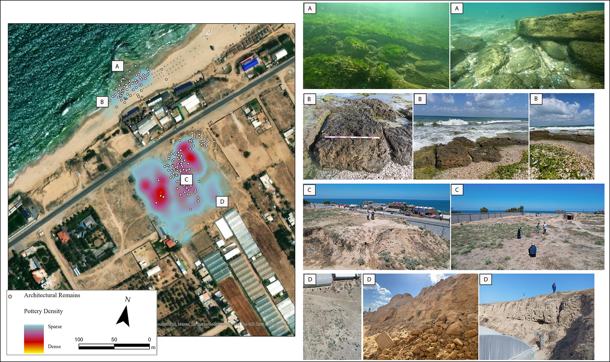
Figure 3. Summary of 2022 observations at Tell Ruqeish. A) underwater features; B) features on the beach; C) survey on the top of the Tell; D) eroding architectural features (aerial photograph by Ain Media; photographs by GAZAMAP; figure by authors).
Remapping Tell es-Sakan
Tell es-Sakan is a Bronze Age site along Wadi Gaza and is central in discussions on the establishment of Egyptian colonies in the Southern Levant during the fourth millennium BC (de Miroschedji et al. Reference de Miroschedji, Sadek, Faltings, Boulez, Naggiar-Moliner, Sykes and Tengberg2001: 80–90; Greenberg Reference Greenberg2019: 57–64). Standing at approximately 30m, it includes 9m of known archaeological layers making it the largest site in Gaza (Figure 4). The exact position of the ancient coastline is unknown, but the now-inland Tell es-Sakan was probably near-coast during the Bronze Age (de Miroschedji et al. Reference de Miroschedji, Sadek, Faltings, Boulez, Naggiar-Moliner, Sykes and Tengberg2001: 97), which is something we confirmed by mapping high concentrations of marine shells on the site.
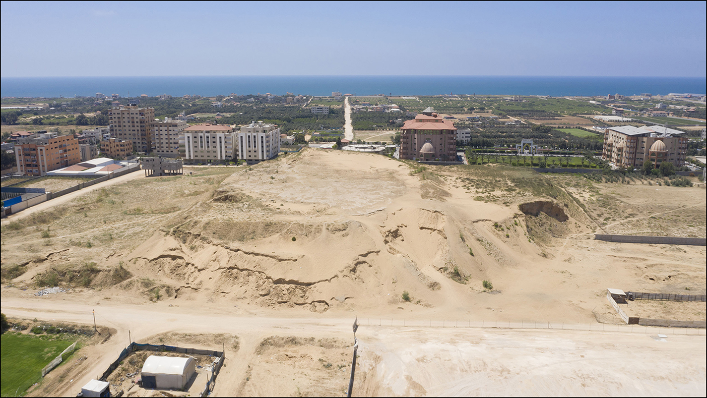
Figure 4. View of Tell es-Sakan toward the Mediterranean Sea (photograph by Ain Media).
Occupying a massive site in an area that is one of the most densely populated and regularly impacted by conflict in the world, Tell es-Sakan required a detailed condition assessment. The survey team used the methods described above to record 6630 observations, remap exposed features and highlight areas for regular monitoring (Figure 5). The team documented high densities of surface finds and accurately outlined the extent of exposed features, which had been partly noted in outdated publications that lack location information (de Miroschedji et al. Reference de Miroschedji, Sadek, Faltings, Boulez, Naggiar-Moliner, Sykes and Tengberg2001). The resulting surface density maps also highlighted areas of actively eroding artefacts, particularly at the west of the Tell (Figure 5). Of note were large, often adjoining ceramic fragments (Figure 6) suggesting recent disturbances caused by erosion and sand digging, which we documented in situ.
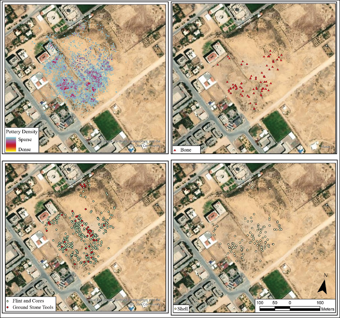
Figure 5. Summary of 2022 observations at Tell es-Sakan (figure by authors).
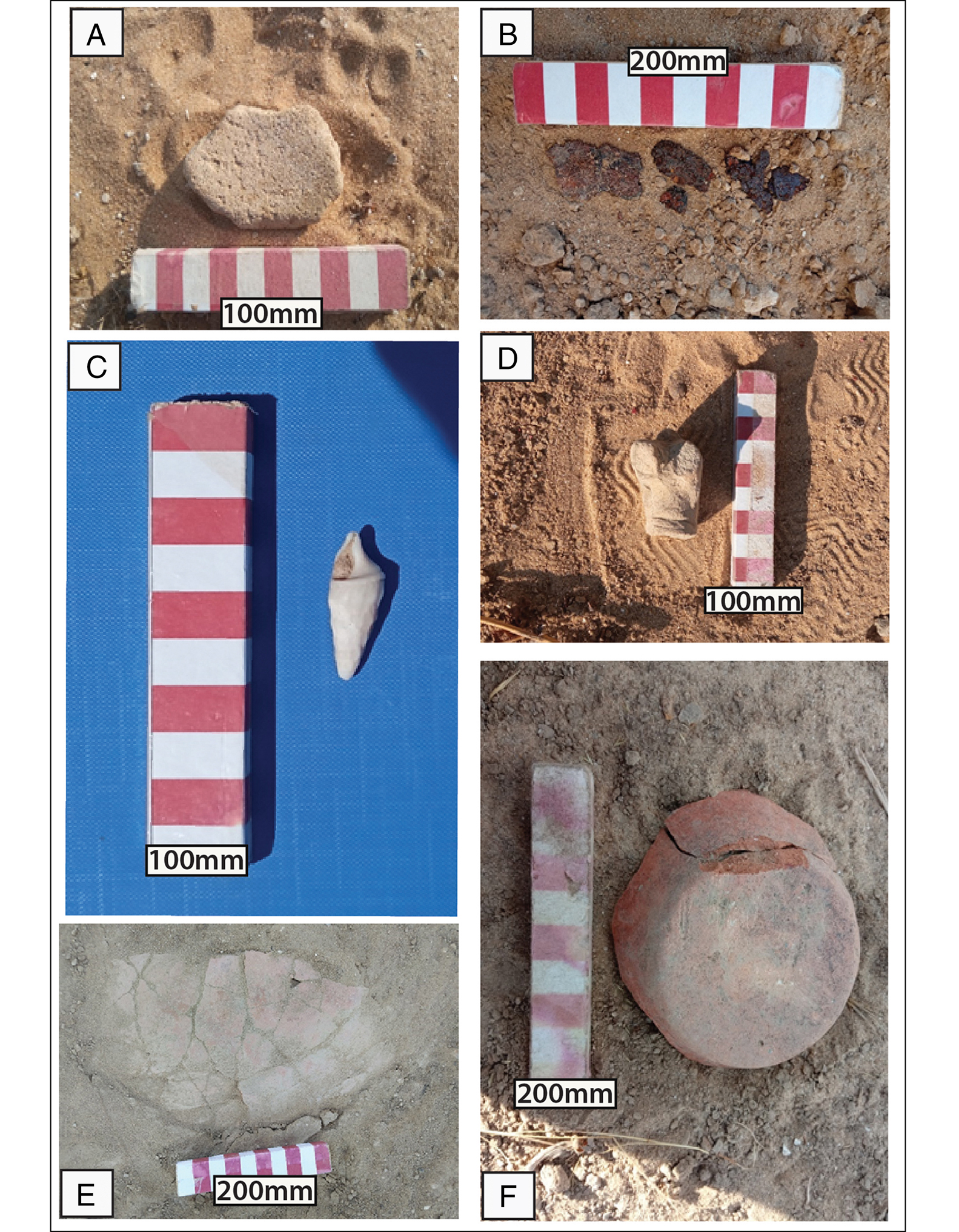
Figure 6. Examples of surface finds at Tell es-Sakan: A) stone tool; B) metal artefact; C) marine shell; D) fragmentary animal figurine; E & F) fragmentary pottery (collected by GAZAMAP; figure by authors).
Discussion
Prior to October 2023, the evolving skills required for the rapid documentation of endangered archaeology existed in Gaza but were dispersed. The most efficient and sustainable way to monitor archaeological sites in this region was to use accessible and low-cost technologies in archaeological training and establish interdisciplinary collaborations with the private sector. GAZAMAP harnessed dispersed expertise through the development of a collaborative network in conjunction with customisable open-access technologies to address the unique monitoring challenges of each site. Reinforcing these partnerships, through continuous training of heritage students and professionals, enabled Gazan partners to take the lead in utilising accessible and open-access tools to document the ongoing devastation of their heritage.
In addition to the humanitarian catastrophe, the destruction of educational infrastructure and the displacement and death of heritage professionals has obliterated prospects for long-term Gazan-led heritage monitoring. While it is not possible to continue GAZAMAP, the project offered a significant baseline for re-assessing damage and informing post-conflict archaeology strategies.
Acknowledgements
We would like to thank the Ministry of Tourism and Antiquities of Palestine for granting us permission to survey the sites. We are grateful to Nic Flemming and the Palestine Exploration Fund. Above all, this project was possible due to the hard work and dedication of our students and partners, three of whom were tragically killed in October 2023 and the rest are currently displaced.
Funding statement
GAZAMAP was funded by the Honor Frost Foundation and the University of Southampton (Faculty of Arts and Humanities). The MarEA Project (University of Southampton, Ulster University), supported the production of training material and data analysis.
References
Andreou, G.M., Fradley, M., Blue, L. & Breen, C.. 2022. Establishing a baseline for the study of maritime cultural heritage in the Gaza Strip. Palestine Exploration Quarterly156: 4–42. https://doi:10.1080/00310328.2022.2037923CrossRefGoogle Scholar
de Miroschedji, P., Sadek, M., Faltings, D., Boulez, V., Naggiar-Moliner, L., Sykes, N. & Tengberg, M.. 2001. Les fouilles de Tell es-Sakan (Gaza): nouvelles données sur les contacts Égypto-Cananéens aux IVe-IIIe millénaires [The excavations at Tell es-Sakan (Gaza): new data on Egyptian-Canaanite contacts in the fourth–third millennia BC]. Paléorient27: 75–104. https://doi.org/10.3406/paleo.2001.4732CrossRefGoogle Scholar
Greenberg, R.2019. The archaeology of the Bronze Age Levant: from urban origins to the demise of city-states, 3700–1000 BCE. Cambridge: Cambridge University Press. https://doi.org/10.1017/9781316275993CrossRefGoogle Scholar
Morhange, C., Taha, M.H., Humbert, J.-B. & Marriner, N.. 2005. Gaza: Évolution des environments et occupation de l’espace depuis l’Âge du Bronze [Human settlement and coastal change in Gaza since the Bronze Age]. Revue Géographique des Pays Méditeranées104: 75–8. https://doi.org/10.4000/mediterranee.2252Google Scholar
Oren, E., Fleming, N., Kornberg, S., Feinstein, R. & Naḥshoni, P.. 1986. A Phoenician emporium on the border of Egypt. Qadmoniot: A Journal for the Antiquities of Eretz-Israel and Bible Lands3/4 (75/76): 83–91.Google Scholar
Zerbini, A. & Fradley, M.. 2018. Higher resolution satellite imagery of Israel and Palestine: reassessing the Kyl-Bingaman amendment. Space Policy. https://doi:10.1016/J.SPACEPOL.2018.03.002CrossRefGoogle Scholar