A show at the Tel Aviv Museum of Art exposes in a thrilling yet disturbing way, from the air and the ground, abandoned villages, fenced-off lands and unrecognized locales
When journalists and researchers tried to obtain satellite photos of the Gaza Strip during the Israeli army operation there last month, they ended up with something that seemed to come from an earlier era – images that were grainy and low-resolution. Although the photos of Gaza and Israel available as part of Google’s free satellite services have recently been updated, their quality is significantly lower than pictures of other parts of the world (including North Korea). According to an article appearing in this paper shortly after the war, the reason is related to a law passed by the U.S. Congress in the 1990s that restricts the quality and availability of commercial satellite images of Israel/Palestine.
An exhibition now on at the Tel Aviv Museum of Art illustrates starkly the impact of limited access to high-quality photography. “Anti-Mapping,” by Miki Kratsman and Shabtai Pinchevsky (curator: Raz Samira), features spectacular images that present an alternative to the official means of mapping that are controlled by the state. Over the course of several years, the two photographers wandered the country documenting sites that are contested both literally and symbolically – on the land and in the public consciousness: Palestinian towns that were destroyed in 1948, unrecognized Bedouin villages, and a string of locales abutting the route of Green Line. Using a variety of technologies, the duo created a detailed mapping of Israel – precisely in places the state sought to erase, obstruct and conceal.
The goal, Kratsman explains, was to expose places that are not shown on maps for two reasons: first, because their names have been completely erased (or, at best, replaced with the word hirbe – “ruin”), and/or their remnants have been covered over by Jewish National Fund forests, Zionist new-towns or IDF bases. And second, because certain parts of these traces are not picked up by low-resolution satellite photography. Although the specific U.S. legislation that prevented the release of high-resolution images from Israel was annulled several months ago, the satellite services, in particular Google, have yet to update their maps.
To counter this, Kratsman and Pinchevsky began working on an alternative mapping project – from the air and the ground. They used drones to take thousands of aerial pictures, and used them to assemble a 3D model using a technique called photogrammetry. Out of 2,500 drone images, one multi-layered photograph was ultimately created and printed for the new exhibition at the incredible resolution of 1.5 centimeters per pixel – more than 100 times greater than what is normally available online. The images were printed on a giant wallpaper that has been installed on the walls of the museum’s photo gallery.
The results are mesmerizing. The works are spread around the exhibition in accordance with the size of the wall and the proportions of the gallery spaces. At first glance you think you’re looking at a familiar satellite image, but upon closer inspection, you’ll discover a rich texture in moving and disturbing detail.
One striking example is the picture of Khan al-Ahmar, next to the Kfar Adumim settlement outside Jerusalem. The village is part of a group of 12 Palestinian refugee communities that are facing expulsion. In these locales, which are part of Area C (i.e., under full Israeli control), drone photography is prohibited, but Kratsman and Pinchevsky managed to elude the soldiers and to record in great detail the everyday life of the people who dwell in tin shacks and tents in this area – lacking the most basic infrastructure of roads, water and electricity. These communities have already been evicted several times; a legal battle is currently ongoing,over a new plan to demolish Khan al-Ahmar, and the school that was built there in 2009 by volunteers out of recycled materials including tires, mud and clay.
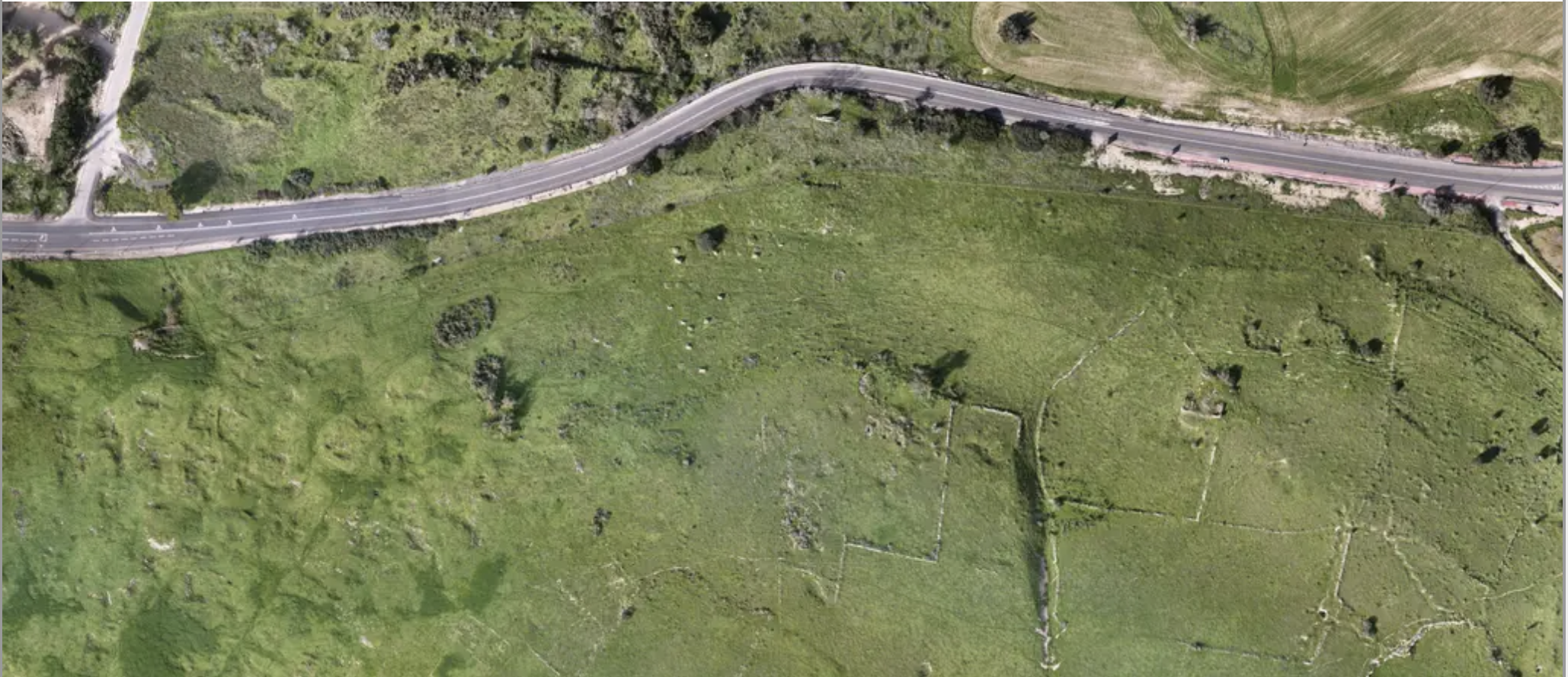
The pair of photographers also documented the village of Al-Araqib near Be’er Sheva, which became a symbol of the Bedouin struggle in the Negev after it was destroyed and rebuilt more than 100 times.
“We roamed around there for several hours trying to find remnants of the village,” Pinchevsky says. “But only when we sent up the drone did we realize that the village was right beneath us. From the air, we could make out the marks of a massive raking of the earth, evidence of the bulldozers that took down the houses and smoothed out the land.”
The images in the show illustrate to what extent aerial photography can reveal details that are not visible from the ground. In a village near Modi’in, for example, the twosome found outlines of streets from an entire village that was erased. From the ground, none of that is visible, but after processing the images from the drone, they saw stone walls that separated parts of what was once a street; in Beit Guvrin, in the central part of the country, they spied remnants of agricultural plots separated by a low stone barrier that’s invisible to the naked eye; and in the village of Hoshen in the Upper Galilee, they observed the remnants of the Muslim village of Safsaf, which was captured by the nascent Israeli army in 1948 in an operation that ended with the massacre of dozens of local residents.
Kratsman and Pinchevsky also took still “portraits” of the sites, at ground level and using regular head-one photography. These sensitive pictures, which expose the interiors and exteriors of tents and shacks, provide an up close and personal view of a place that supplements the quasi-scientific perspective from up above. With the understanding that nothing will remain just as it was at the moment the photos were taken, each image in the project is accompanied by its exact coordinates, altitude and a time stamp. Thus, the “Anti-Mapping” project constitutes an archive of the present and a tool for comparison in the event of any future change, erasure, demolition (or perhaps rebuilding).
Kratsman and Pinchevsky selected the sites by cross-referencing information from several sources: conversations with residents, the “Nakba Map” created by the Zochrot nonprofit, the Negev Coexistence Forum for Civil Equality, and Salman Abu Sitta’s “Atlas of Palestine.”
Kratsman, a leading Israeli human rights activist, has been documenting unrecognized villages in the Negev for more than a decade, usually with the inhabitants’ full cooperation. Pinchevsky, who was Kratsman’s student in the photography department of the Bezalel Academy of Arts and Design in Jerusalem, is currently completing his master’s in art at Northwestern University in Illinois. His works typically deal with the relationship between photographic techniques and the Israeli occupation – for example, by means of a simulator that imagines flight over pre-1948 Israel, entitled “A Bruising Gaze on a Faltering Landscape.” s. Together, Kratsman and Pinchevsky see the practice of cartography and photography work as a thoroughly political act that aims to impose an ideological agenda on the cultural domain.
The “Anti-Mapping” show, which is on through October 2, underscores the need to return to museum and gallery spaces after a year of online exhibitions and digital art, due to the coronavirus pandemic. “The audience’s movement into the image is essential,” says Kratsman, adding that he continues to discover new details in the pictures each time he looks at them. Indeed, as you wander about in the gallery space, the quality of the artists’ work comes to the fore and spurs the viewer to search for more details in each image. Between the aesthetics of the satellite and other imagery and the violence these images seek to present lies the protest of the artists, who with this project are taking a stand against the privileged status of those who are given the tools to see. Between the aesthetics of the satellite and other imagery and the violence the images present lies the protest of the artists, who with this project are taking a stand against the privileged status of those who are given the tools to see.
“Right now only a few – spy agencies and private companies – have access to this information,” Pinchevsky notes. “And if there’s something that should be demanded in this time we live in, it is that everyone should have the right to see.”